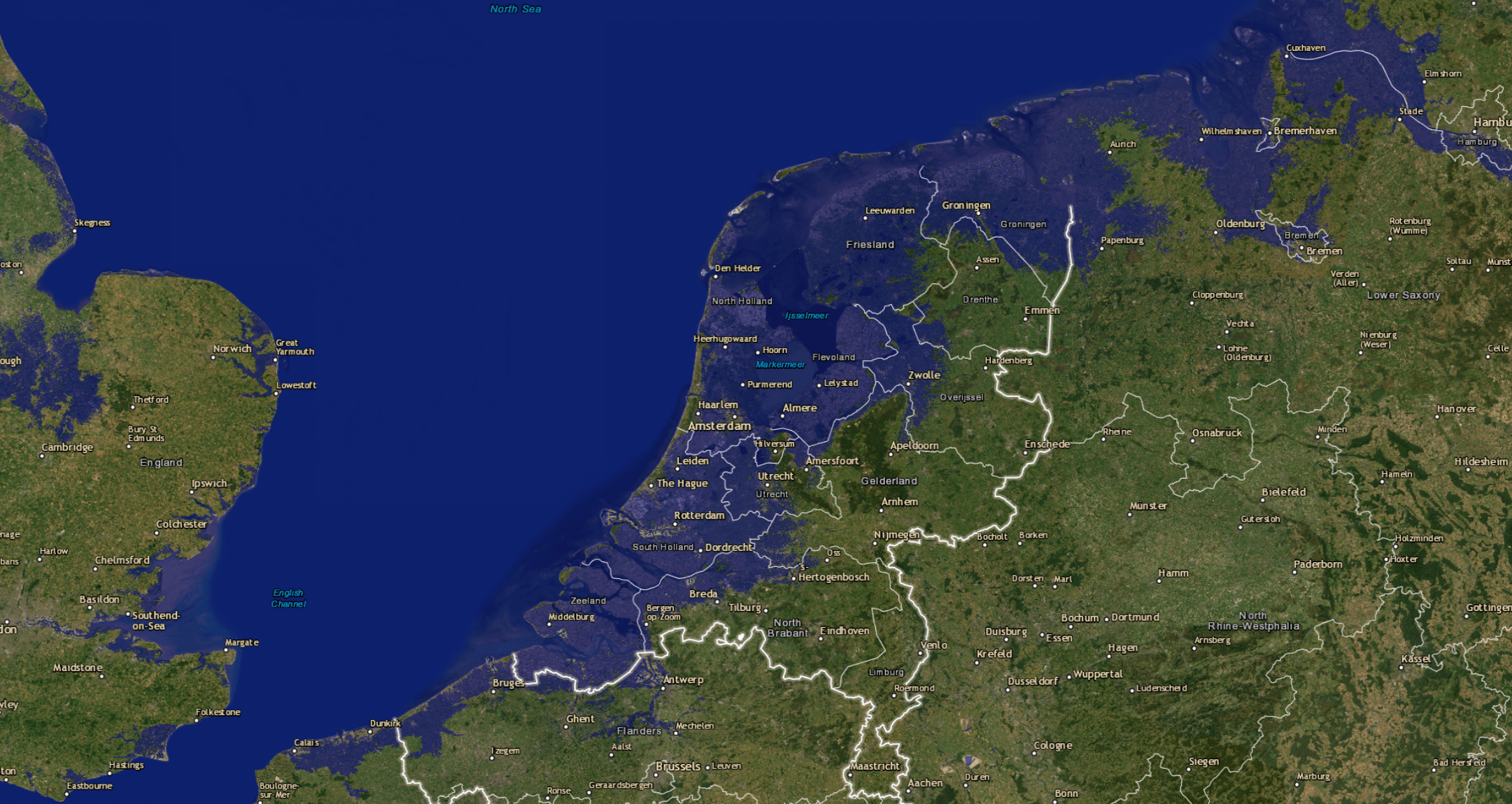
Paesi Bassi se il livello del mare aumenta di 2 metri (e se si rimuovono tutte le difese contro le inondazioni)
https://i.redd.it/5jn3aictuide1.png
di whywalk

Paesi Bassi se il livello del mare aumenta di 2 metri (e se si rimuovono tutte le difese contro le inondazioni)
https://i.redd.it/5jn3aictuide1.png
di whywalk
18 commenti
Ik maak mij niet veel zorgen hier in Zwolle, woon toch op de eerste verdieping.
‘Den Bosch aan zee’ klinkt niet slecht.
Noyja opzich. Met de boot naar engeland vanuit utrecht is wel chill. Niet zover meer hoeven rijden is goed voor t milieu.
Alleen maar winst dus
Kijk, de truc is om de waterwerken dus _niet_ weg te halen zegmaar.
Deze kaartjes zijn onzinnig voor de Nederlandse situatie; want het enige wat het doet is stukjes land met een bepaalde hoogte blauw kleuren. Dus: elevation < sea level = blue. Maker van de kaart heeft voor Nederland wel een aanpassing gedaan, maar zodra je 2 meter zeeniveau aanklikt zet je een groot deel onder water wat in de praktijk gewoon droog zal zijn.
> The calculation of each tile is quite simple. If that coordinate is at the given level or below, then the tile is coloured blue, otherwise it is left transparent. There’s a slight cheat for areas of the world that are currently below sea level (large parts of the Netherlands for example)… Such areas are actually listed as +1m in my data files, so they appear dry at +0 metres, but flooded for any other value. Areas that are naturally at exactly sea-level are always coloured blue regardless, that’s why this map of England’s fen-land is peppered with blue, even at +0m: fenland at +0m
[Zie](https://blog.firetree.net/2006/05/18/more-about-flood-maps/).
Deze kaartjes zijn dus voor de Nederlandse situatie misleidend, want het model is daar niet goed op ingericht.
Daarnaast heeft de kaart nog meer beperkingen. Zoals dat het geen rekening houdt met flood defences (wat OP hier wel benoemd, maar op MapPorn niemand.)
> Fifthly, I don’t take any account of coastal defences. It’s obviously possible to build defences that protect habitable land far below sea level. I’ve got no way of knowing whether current defences (in Holland, say) are able to withstand an extra +1 metre of mean sea level. I imagine that the impact would depend upon how quickly the oceans rise, and how much money was available for building new defences.
ik trek me zwembandjes vast aan!
Ik heb altijd al een zeewater aquarium willen hebben!
Zo te zien is het tijd om een snorkel te kopen.
Zuid Limburg hier, ik zit lekker hoog en droog
Je kan diezelfde gebieden nu ook al voor een groot deel blauw kleuren. Onzinnig kaartje dit.
At least people in the Randstad will stop looking down on the rest of us.
Ooh no what will we do now. Geas wil just have to build more dikes and pump out that little bit of water.
Wow, eindelijk een kaart die niet ophoudt bij de grens. De ooster- en zuiderburen mogen ook verzuipen.
Thank God I live on a terp.
We know thats why we have ‘m.
Sinds wanneer word Heerhugowaard aangegeven op een kaart ipv Alkmaar 😆
I think the Netherlands is probably the best prepared country for rising sea levels. They’ve been playing this game for centuries.
amsterdam ligt alleen maar droog volgens dit kaartje omdat er zoveel bebouwing is, alleen west en centrum ligt boven NAP maar zeker geen meter