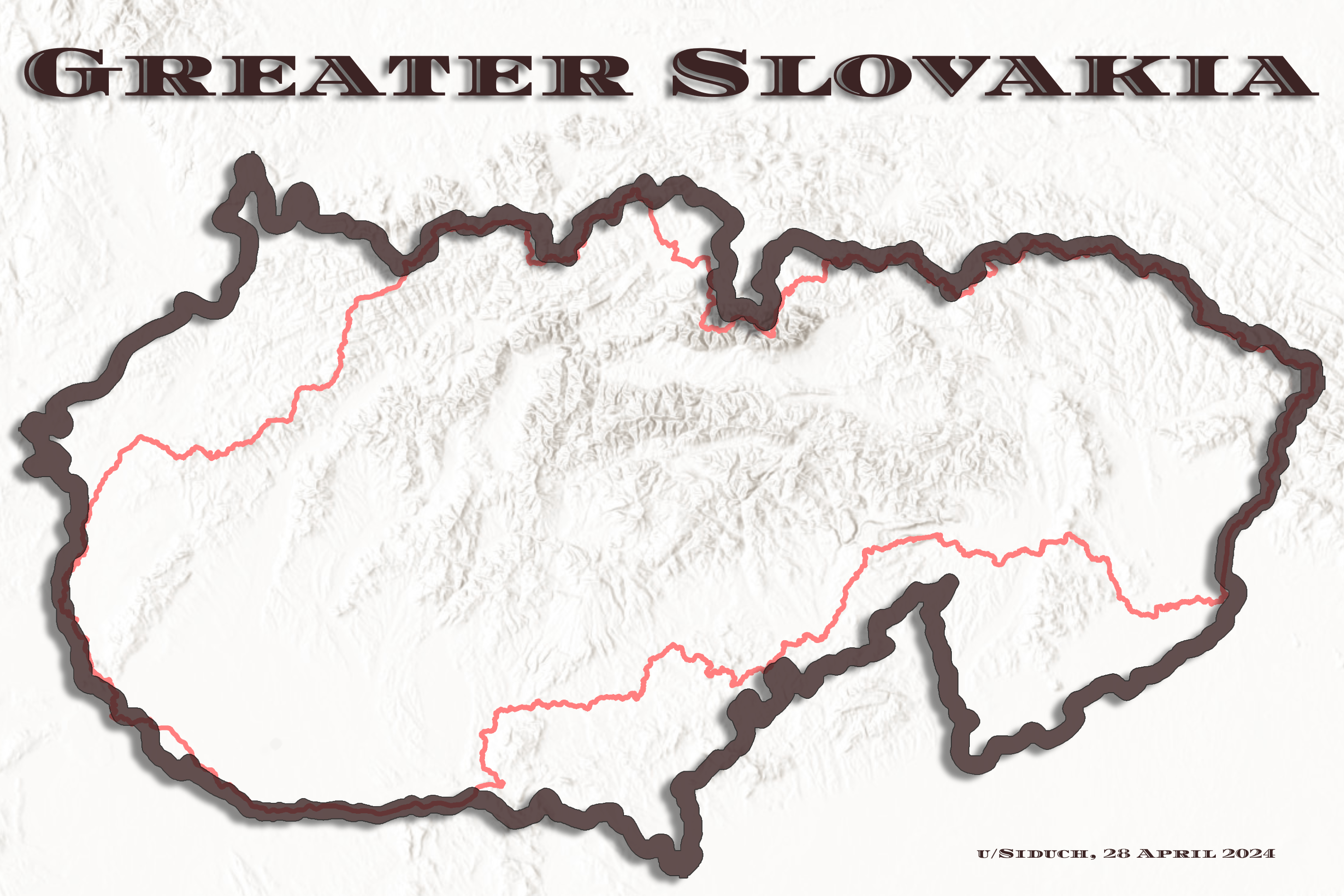
Ahojte! I made this map cuz I was a lil bored and was in a patriotic mood…
It is an imaginary idea of Slovakia, if the 1848 Uprising turned out with the initial borders of the uprising. (i.e., the outer border of the counties of the Kingdom of Hungary within the Slovak lands) This constitutes the all extra land seen here except for that in Czechia. [https://commons.wikimedia.org/wiki/File:Autonomia1848.png]
The extra land from Czechia (Moravia) is from a Slovak Nationalist political concept from WWII known as [Veľké Slovensko](https://sk.wikipedia.org/wiki/Ve%C4%BEk%C3%A9_Slovensko) (separate from the title of this map), whereby the Slovaks requested multiple times that they receive the Eastern Moravian Land (aka Moravian Slovakia). For the purpose of this map, I used a dialects map of Moravia, in which the area used is labelled, “Eastern Moravian dialects (sometimes considered also as Western Slovakian dialects).” [https://commons.wikimedia.org/wiki/File:Map_of_Moravian_dialects.png]
In the end, the only extra land in this Greater Slovakia that could actually be argued for Slovaks is that of Polish Orava and Spis, which have historically been Slovak lands up until the past century.
Hrdina_Imperia on
Založené. Srandy kopec, ale keby chceme, môžeme južnú hranicu potiahnuť až k Blatnohradu.
LeCockExceptionelle on
Lol, slovac dosla k vlastnemu statu ako slepe kura k zrnu, ani ten si poriadne nevie spravovat a je nefunkcny, a este niekoho napadne, ze by mohol/mal byt vacsi?
B3nzelDeAt on
A Budapešť kde ?
roderik35 on
Mne tam chýba Podkarpatská Rus, ale to by som nechal na tamjšie obyvateľstvo, či majú záujem o návrat.
Ďalej Békešká Čaba a Segedín. Slovensko by malo mať hranice s Rumunskom a Srbskom.
Hlavné mesto by som presul do Vyšehradu, Košíc alebo Ostrihomu.

5 commenti
Ahojte! I made this map cuz I was a lil bored and was in a patriotic mood…
It is an imaginary idea of Slovakia, if the 1848 Uprising turned out with the initial borders of the uprising. (i.e., the outer border of the counties of the Kingdom of Hungary within the Slovak lands) This constitutes the all extra land seen here except for that in Czechia. [https://commons.wikimedia.org/wiki/File:Autonomia1848.png]
The extra land from Czechia (Moravia) is from a Slovak Nationalist political concept from WWII known as [Veľké Slovensko](https://sk.wikipedia.org/wiki/Ve%C4%BEk%C3%A9_Slovensko) (separate from the title of this map), whereby the Slovaks requested multiple times that they receive the Eastern Moravian Land (aka Moravian Slovakia). For the purpose of this map, I used a dialects map of Moravia, in which the area used is labelled, “Eastern Moravian dialects (sometimes considered also as Western Slovakian dialects).” [https://commons.wikimedia.org/wiki/File:Map_of_Moravian_dialects.png]
In the end, the only extra land in this Greater Slovakia that could actually be argued for Slovaks is that of Polish Orava and Spis, which have historically been Slovak lands up until the past century.
Založené. Srandy kopec, ale keby chceme, môžeme južnú hranicu potiahnuť až k Blatnohradu.
Lol, slovac dosla k vlastnemu statu ako slepe kura k zrnu, ani ten si poriadne nevie spravovat a je nefunkcny, a este niekoho napadne, ze by mohol/mal byt vacsi?
A Budapešť kde ?
Mne tam chýba Podkarpatská Rus, ale to by som nechal na tamjšie obyvateľstvo, či majú záujem o návrat.
Ďalej Békešká Čaba a Segedín. Slovensko by malo mať hranice s Rumunskom a Srbskom.
Hlavné mesto by som presul do Vyšehradu, Košíc alebo Ostrihomu.