I can’t find the Romanians; I suppose they were still living in India at that time?
LaurestineHUN on
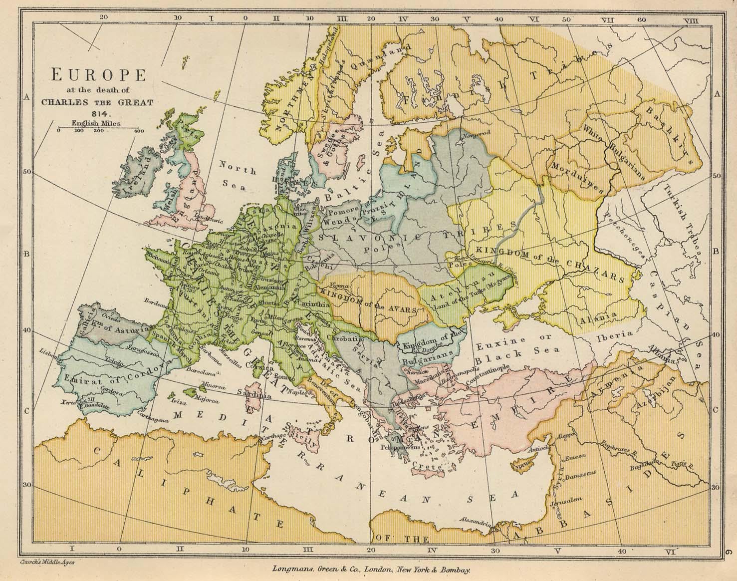
That’s some cursed Etelköz there
HexMusie on
Beautiful map. Hard to believe this was one of the few moments in history when most of Western Europe was united under one ruler.
Drahy on
Why does it say England instead of Angles, Saxons and Danes? Same with Ireland.
FabioSein on
We are European, and I really feel that.
We need to be more joined-> federal? Maybe
MintCathexis on
It is worth noting that the exact borders were not well defined in those times.
It would appear that this map tries to superimpose medieval state names on top of modern-day borders. As someone from the Balkan region, I can clearly see that the borders of regions correspond to borders of countries after Ottoman invasion. There are a few duchies missing, most notably Bosnia and Duklja.
Positioning and borders of Balkan duchies and polities which *are* represented on the map is also off. Croatia should be more south and more bulbous as Slavic tribes in Panonia did not identify as Croats until after Croatian King Tomislav defeated Pannonian Avars in 10th century (Pannonian Slavs henceforth identified as Croats), and duchy of Croatia extended to western part of the region of Herzegovina. Minor duchies Zachumlia and Travunia made up the rest of Herzegovina that overlaps with what is marked as “Servia” on the map. Serbia itself was more east at that time and was involved in border raids and wars with Bulgarians.
As for Greece, it was way more fragmented than is shown here.
That’s just Balkans, I would imagine any other region is poorly represented as well. Italy is looking mighty suspicious, too. Also, not so sure about Saxony even though this *is* supposed to be immediately after Frankish conquest of Saxony so I guess it’s mostly fine to put entire of Saxony inside the Frankish empire, but there was plenty of flux there too.
MysticSquiddy on
I don’t think New York existed at the time, sorry mate
coltspades on
Americans after realising they are Friendly firing on their kind by Talking shi about europe.
MatchAltruistic5313 on
This Servia never existed and it’s borders are greatly exaggerated.
trejj on
Yes, Finnish Tribes ruled over Russia. Didn’t Putin want to return the world maps to the historic glory? Eagerly awaiting for his capitulating resignation of the Finnish land.
Master__of_Orion on
Iberia in todays Georgia? Interesting.
sant2060 on
How was this map created? It’s clearly NOT made in 814, so it’s someones later interpretation of that period.
I can just say, situation decipted here in Balkans is tricky. It’s not that is not possible, it’s just that we have no fcking clue.
From what I see, several very important tribes are missing. Or are just lumped together unto what they weren’t.
Now I checked, it’s from 1905. Author probably went for full simplification in this area, because it’s a gray area (actually shown in grey colour on map 🙂 )
yamiherem8 on
Why are there poles in Kiev?
Scary_Examination841 on
The Abbasids have come right up to my city 🙁
Prestigious_Tie_7967 on
Why is there a kiev but not moscow hmmm
StepOk8147 on
It looks like an AI fake.
BeatTheMarket30 on
Emirat of Cordova, that’s funny
cool_waterz on
Case in point that the whole “this is our sacred land and these are our borders forever more” – in other words nationalism – is utter bollocks.
I keep going back to the more than compelling fact that many animal species migrate; they follow the seasons, food sources, seek out safe places to give birth and rear their young.
It’s nuts that we humans restrict ourselves into tiny geographical areas and create myths around this self-imposed imprisonment.
Birziaks on
The map shows Slavic tribes living to the extend of modern Kaunas, where Neris and Nemunas rivers meet. So it is basically saying that Lithuanians are Slavic people. As you would have Somigitians to the west, Yotvingians to the south west and Zemgalians to the north.
Sooo yeah, the whole sections of eastern Balts are marked as Slavic.
Demonbaby_Wot on
No Russia…must have been nice.
dembelikuvar on
Servia Stronk unlike puny chobathia 😂
OO-MA-LIDDI on
The political unification of England occurred in 927, so that’s one inaccuracy.

23 commenti
[Source](https://maps.lib.utexas.edu/maps/historical/history_colbeck_1905.html)
I can’t find the Romanians; I suppose they were still living in India at that time?
That’s some cursed Etelköz there
Beautiful map. Hard to believe this was one of the few moments in history when most of Western Europe was united under one ruler.
Why does it say England instead of Angles, Saxons and Danes? Same with Ireland.
We are European, and I really feel that.
We need to be more joined-> federal? Maybe
It is worth noting that the exact borders were not well defined in those times.
It would appear that this map tries to superimpose medieval state names on top of modern-day borders. As someone from the Balkan region, I can clearly see that the borders of regions correspond to borders of countries after Ottoman invasion. There are a few duchies missing, most notably Bosnia and Duklja.
Positioning and borders of Balkan duchies and polities which *are* represented on the map is also off. Croatia should be more south and more bulbous as Slavic tribes in Panonia did not identify as Croats until after Croatian King Tomislav defeated Pannonian Avars in 10th century (Pannonian Slavs henceforth identified as Croats), and duchy of Croatia extended to western part of the region of Herzegovina. Minor duchies Zachumlia and Travunia made up the rest of Herzegovina that overlaps with what is marked as “Servia” on the map. Serbia itself was more east at that time and was involved in border raids and wars with Bulgarians.
As for Greece, it was way more fragmented than is shown here.
That’s just Balkans, I would imagine any other region is poorly represented as well. Italy is looking mighty suspicious, too. Also, not so sure about Saxony even though this *is* supposed to be immediately after Frankish conquest of Saxony so I guess it’s mostly fine to put entire of Saxony inside the Frankish empire, but there was plenty of flux there too.
I don’t think New York existed at the time, sorry mate
Americans after realising they are Friendly firing on their kind by Talking shi about europe.
This Servia never existed and it’s borders are greatly exaggerated.
Yes, Finnish Tribes ruled over Russia. Didn’t Putin want to return the world maps to the historic glory? Eagerly awaiting for his capitulating resignation of the Finnish land.
Iberia in todays Georgia? Interesting.
How was this map created? It’s clearly NOT made in 814, so it’s someones later interpretation of that period.
I can just say, situation decipted here in Balkans is tricky. It’s not that is not possible, it’s just that we have no fcking clue.
From what I see, several very important tribes are missing. Or are just lumped together unto what they weren’t.
Now I checked, it’s from 1905. Author probably went for full simplification in this area, because it’s a gray area (actually shown in grey colour on map 🙂 )
Why are there poles in Kiev?
The Abbasids have come right up to my city 🙁
Why is there a kiev but not moscow hmmm
It looks like an AI fake.
Emirat of Cordova, that’s funny
Case in point that the whole “this is our sacred land and these are our borders forever more” – in other words nationalism – is utter bollocks.
I keep going back to the more than compelling fact that many animal species migrate; they follow the seasons, food sources, seek out safe places to give birth and rear their young.
It’s nuts that we humans restrict ourselves into tiny geographical areas and create myths around this self-imposed imprisonment.
The map shows Slavic tribes living to the extend of modern Kaunas, where Neris and Nemunas rivers meet. So it is basically saying that Lithuanians are Slavic people. As you would have Somigitians to the west, Yotvingians to the south west and Zemgalians to the north.
Sooo yeah, the whole sections of eastern Balts are marked as Slavic.
No Russia…must have been nice.
Servia Stronk unlike puny chobathia 😂
The political unification of England occurred in 927, so that’s one inaccuracy.